Planes on maps
Otti sent me a link to a protocol called SBS1. It seems to also goes by the name of BaseStation protocol. It’s a very simple comma separated text based protocol for specifying positional information. Anything you don’t know you just don’t put in. To specify where a plane is a message such as MSG,3,,,AES,,,,,,Call,ALT,,,LAT,LONG,,,0,0,0,0 will do if you replace AES, Call, ALT, LAT, and LONG with the appropriate values. For heading and speed MSG,3,,,AES,,,,,,Call,,Speed,Track,,,VerticalRate,,0,0,0,0 might do.
From my minimal looking around this protocol seemed to be quite well supported by other applications so I decided to implement it in JAERO to allow better connectivity between JAERO and other applications that want positional information of planes.
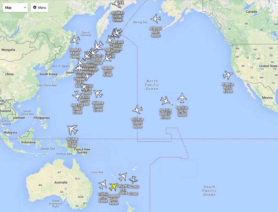
Connecting JAERO to VRS using the SBS1 protocol I got some planes appearing on the map.

Planes plotted on a map from data decoded using C-band signals off the I3 POR satellite
The first problem I noticed was as VSR was designed to be used with ADSB, the slow update times between airplanes broadcasting their location via Aero Satcom meant the planes could disappear from the map before their next transmission. VSR limits this timeout to a maximum of nine minutes. I emailed Andrew the VRS guy about this limitation and he has released a preview version of VRS that allows a timeout of up to 5 hours to be set; this solves the problem.
Plane tracks
I can see why people get into plane spotting via computer. It can kinda be fascinating watching what they’re up to.
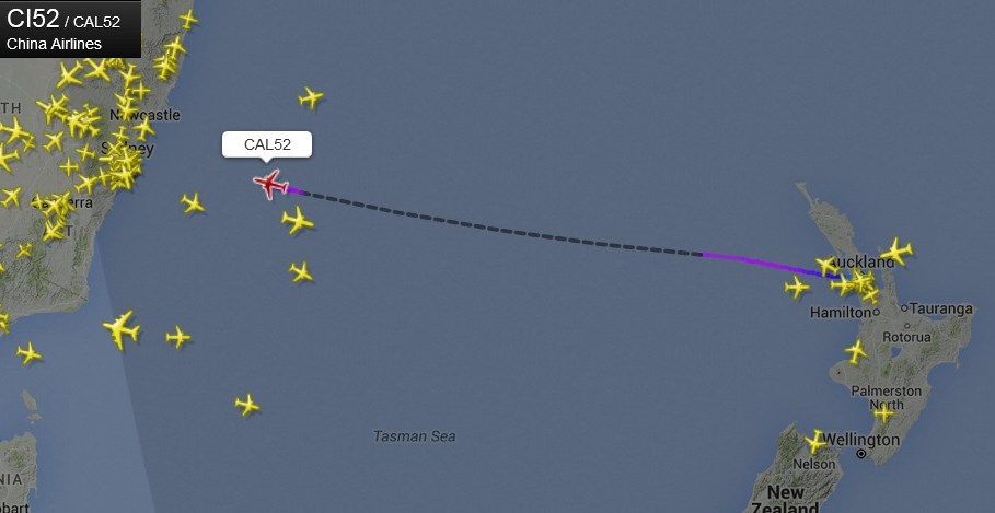
Closer to home I looked at an airplane going from Auckland to Sydney over the Tasman Sea. Here we call this crossing the ditch. But this ditch is big enough that planes are out of ADSB range for a good portion of the crossing. So when you go to one of those online tracking sites these planes vanish for a period. This can be seen in the dotted black line in the following figure I got from FlightRadar24. The dotted black line means there was no ADSB messages received from the plane.

Black dotted line indicates plane disappears from ADSB tracking over Tasman Sea
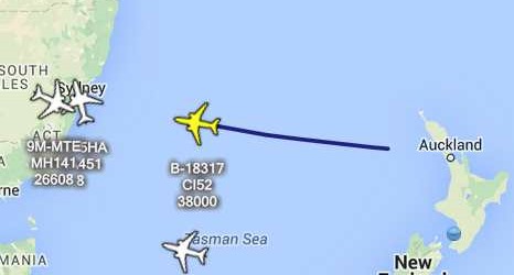
I just so happened to be also monitoring this plane from signals it sent via the POR (Pacific Ocean region) I3 satellite. I don’t know exactly how often I was receiving positional location updates via satellite but it seemed to be around every 15 minutes. I also noticed I did not get any updates via satellite when the airplane was within ADSB range. My entire tracking of the airplane from Auckland to Sydney via satellite can be seen in the following figure.

Plane being tracked via satellite from Auckland to Sydney when out of ADSB range
With both ADSB and satellite this plane could be tracked for its entire journey. while this particular plane only transmitted positional information when it was out of ADSB range, this is not always the case. As can be seen from the previous figure there are some airplanes around Sydney who are within ADSB range that are still transmitting their locations via satellite.
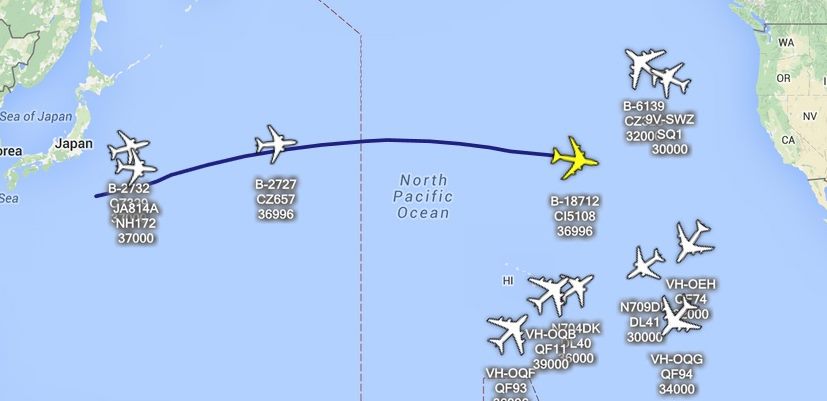
Leaving the computer running a few hours I obtained a longer track from a plane a bit further north going from Taiwan to Los Angeles.

Big flight from Taiwan to Los Angeles
PlanePlotter integration
PlanePlotter is a very popular planes on map application. They have a network of receivers to provide coverage around the world. Recently Bev the programmer has been implementing support for JAERO to improve their network coverage over the parts of the world that have no ADSB coverage. This support for JAERO should be released by him very soon and has probably already been released by the time you’re reading this. Apparently they already have some people who are ready to point dishes into the sky.
Other miscellaneous things of interest
Europe seems to be well served by the Inmarsat 3 series of satellites. A guy in the UK has successfully obtained signals from IOR, AOR-E and AOR-W. This covers an area from the West Coast of America to the East Coast of Australia going east; about two thirds of the surface of the earth. He is doing this off a 1.5 m dish which is the smallest dish so far someone has had success from. He’s noticed some problems with the IOR satellite in that it seems to have a rather inclined orbit. This means rather than staying still it moves a bit during the day, in turn this causes a loss of packets during some times of the day if the dish is not realigned. However, IOR is a very marginal satellite from the UK.
Another person from UK, but this time using a 1.8 m dish, discovered that there were actually R and T channels on the L band coming from AOR-E ( 15.5° West ). These packets are the same type as can be found on the C-band and contain positional information. However, before you get your hopes up and thank you don’t need a C-band dish to get positional information, he found these packets were very weak even of a 1.8 m dish and found the C-band ones were much stronger on the same 1.8 m dish. I don’t think these signals are supposed to be there and it is possible they are there just because some faulty hardware that is leaking C-band signals onto the L band.
Tuning C-band burst
There is no tuning required for C-band burst in JAERO and the usual slider for setting frequency and AFC controls do nothing. As long as JAERO hears all the signal you are fine. Ideally you don't want to place the signal too close to 0 Hz or 24 kHz. Also you don't want any neighboring channels to interfere with the one you want to receive as the decoder may try to lock onto these signals. The following figure shows good alignment of the audio frequency where the yellow line represents the center of the last received signal.

Good alignment of the audio frequency
It's not critical to remove the low-frequency or high-frequency noise so allowing a larger bandwidth through is also fine where the audio frequency of the signal is somewhere in the middle of the audio frequencies you let through. The following figure shows good alignment too where the yellow line represents the center of the last received signal.

Also good alignment of the audio frequency
Placing the signal too close to 0 Hz or or 24 kHz is not desirable for a couple of reasons. Firstly the demodulator algorithm creates what is called the analytic signal which is not as accurately calculated for the low-frequency and this is used for timing estimation. Secondly the transmissions from each airplane is slightly different and depends on the hardware and the velocity of the airplane, this potentially means the frequencies going into the demodulator will drop below 0 Hz.
Finally
It looks like the era for satellite planes on maps may have finally arrived. More and more people are either trying C-band Aero out or planning to try it out. These are truly exciting time.
Jonti 2016
Home